3D model of Pavlohrad — buy a printed city map
The 3D map of Pavlohrad is printed from open map data: buildings get their real height, roads their width, parks and water a colour of their own. Any part of the city can be ordered, from the centre to the outskirts.
Maps from ≈€8, map keychains from ≈€4. Production takes 2–4 working days. You can also buy just the 3MF file to print yourself.
Pavlohrad is a city in Dnipropetrovsk Oblast with 101,430 residents (2022) and about 1,719 people/km². Dnipro lies 61 km to the west.
On a 3D map the city is recognised first by its water (Vovcha) — the anchors people look for first.
At 59 km² the whole city will not fit one model — people usually pick the centre or their own neighbourhood at 8–11 cm.
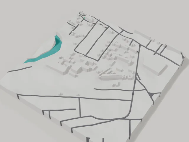
Pavlohrad was founded in 1779 on the Vovcha river, is home to about 101 thousand people and lies 61 kilometres from Dnipro. The area for the 3D map is an 800 by 800 metre square in the centre: 172 buildings, 3.2 floors on average, the tallest at 5 floors. The townscape is even and low, so the streets read from edge to edge on the model.
The frame takes in the Vovcha river, printed in a separate colour and running as a natural line across the area. There is also the monument to Zhozef Kotin, the heavy tank designer born in Pavlohrad. A map of the centre suits anyone who wants the city at home, while a map of your own block becomes a personal gift. Buy a 3D model or order a map in the builder, where the frame is easy to move.
Pavlohrad at a glance
- Population
- 101,430 (2022)
- Area
- 59 km²
- Density
- 1,719 people/km²
- Region
- Dnipropetrovsk Oblast
- Water
- Vovcha
- Founded
- 1779
What your 3D model of Pavlohrad will show
An 800 × 800 m square around the centre of Pavlohrad holds about 172 buildings, each with its real height. The tallest building in frame has 5 floors, 3.2 on average.
What the area is like: low-rise blocks — streets and terrain show especially well.
Water in frame: Вовча — slightly lower than the ground, so the shoreline reads in relief.
Recognisable places inside the area: Жозефу Яковичу, конструктору важких танків.
Data: OpenStreetMap, 800 × 800 m area.
How to order a 3D map of Pavlohrad
- Open the builder — it starts right at the centre of Pavlohrad. Move the frame to your district, street or yard.
- Choose size and style (with or without relief) — the preview is ready in a few minutes.
- Order the print and enter the delivery details — we print it in 2–4 working days.
Prices — Pavlohrad
- Carte 3D de ville — S (≈5,5 cm)350 ₴ · ≈8 €
- Carte 3D de ville — M (≈8 cm)500 ₴ · ≈12 €
- Carte 3D de ville — L (≈11 cm)750 ₴ · ≈18 €
- Carte 3D de ville — XL (≈15 cm)1250 ₴ · ≈30 €
- Carte 3D de ville — 20 cm1650 ₴ · ≈40 €
- Relief du terrain (option)+100 ₴
- Aimant-carte de frigo (≈6 cm)210 ₴ · ≈5 €
- Porte-clés carte (impression 3D)dès 170 ₴ · ≈4 €
FAQ
- How many buildings will the 3D model of Pavlohrad have?
- An 8 cm map of an 800 × 800 m area holds about 172 buildings, the tallest with 5 floors. Resize or move the frame and the count changes — the builder preview shows the exact result.
- Will Жозефу Яковичу, конструктору важких танків be visible on the model?
- Yes — Жозефу Яковичу, конструктору важких танків lies inside the area shown for this page. Move the frame in the builder to put it right in the centre.
- Comment payer une commande ?
- Paiement par carte en ligne (Visa/Mastercard via LiqPay) ou à la livraison — au choix lors de la commande.
- Quel quartier de Pavlohrad choisir ?
- Les zones variées rendent le mieux : quelques rues, un parc ou de l'eau — le quartier reste reconnaissable au premier coup d'œil. Une zone trop grande rend les détails trop petits.