3D model of Poltava — a model of your neighbourhood
A 3D map of Poltava is a tactile three-dimensional model of a district: streets, buildings with real heights, parks and rivers from OpenStreetMap data. Pick any district of Poltava in the builder — the model is ready in minutes as a 3MF or STL for Bambu Studio or PrusaSlicer.
No 3D printer? We print the map or a Poltava map keychain in eco-friendly Eco PLA and ship across Ukraine. A perfect gift for anyone who loves their city.
Column of Glory and the Vorskla are what people look for first on the model. The remaining blocks act as a backdrop that sets the scale.
At 103 km² the city fits into a single model without losing detail. Here a density of 2,714 people per km² gives an even block rhythm, and the map reads as one continuous fabric.
The city is roughly 850 years old, so regular later blocks sit next to an irregular historic centre.
The region is Poltava Oblast. A print usually covers 1–3 km² around the centre: at that scale buildings stay separate volumes instead of merging into a slab.
Poltava at a glance
- Population
- 279,593 (2022)
- First mentioned
- 1174
- Area
- 103 km²
- Water
- Vorskla
- Region
- Poltava Oblast
- Landmark
- Column of Glory
- Density
- 2,714 people/km²
- City age
- 852 years
Poltava was first mentioned in 1174, covers 103 square kilometers by the Vorskla River, and had nearly 280 thousand residents in 2022. The Monument of Fame serves as the landmark of this regional center. A desktop 3D model sized at 8 centimeters captures an 800 by 800 meter square around the center. This specific sector holds 270 buildings with an average height of 2.9 floors and a maximum height of 9 floors.
The printed miniature displays precise outlines of the Gogol Theater, the Puppet Theater, the Cadet Corps, the Yaroshenko Art Museum, the Ivan Kotlyarevsky Monument, and the Monument of Fame. Green spaces are also detailed, including the Corpus Garden, the Alley of Gogol Characters, Hryhoriy Skovoroda Square, and Andriy Orlov Student Square. It makes a memorable gift for anyone connected to the city. You can order a map after checking the free model preview in our customizer.
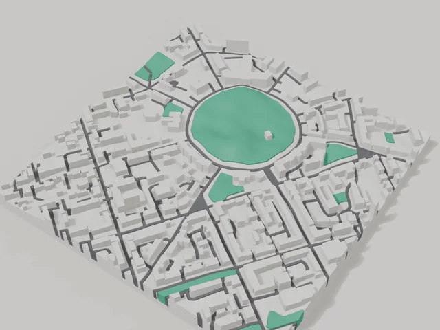
What your 3D model of Poltava will show
An 800 × 800 m square around the centre of Poltava holds about 270 buildings, each with its real height. The tallest building in frame has 9 floors, 2.9 on average.
What the area is like: low-rise blocks — streets and terrain show especially well.
Green areas printed in a separate colour: Студентський сквер імені Андрія Орлова, Алея гоголівських героїв, сквер імені Григорія Сковороди, Корпусний сад.
Recognisable places inside the area: Театр імені Гоголя, Театр ляльок, Полтавський художній музей (галерея мистецтв) імені Миколи Ярошенка, Кадетський корпус, Монумент Слави, Пам'ятник Івану Котляревському.
Data: OpenStreetMap, 800 × 800 m area.
Prices — Poltava
- 3D city map — S (≈5.5 cm)350 ₴ · ≈8 €
- 3D city map — M (≈8 cm)500 ₴ · ≈12 €
- 3D city map — L (≈11 cm)750 ₴ · ≈18 €
- 3D city map — XL (≈15 cm)1250 ₴ · ≈30 €
- 3D city map — 20 cm1650 ₴ · ≈40 €
- Terrain relief (option)+100 ₴
- Fridge magnet map (≈6 cm)210 ₴ · ≈5 €
- Map keychain (3D print)from 170 ₴ · ≈4 €
FAQ
- How many buildings will the 3D model of Poltava have?
- An 8 cm map of an 800 × 800 m area holds about 270 buildings, the tallest with 9 floors. Resize or move the frame and the count changes — the builder preview shows the exact result.
- Will Театр імені Гоголя be visible on the model?
- Yes — Театр імені Гоголя lies inside the area shown for this page. Move the frame in the builder to put it right in the centre.
- How long does production take?
- Making a map or keychain with a Poltava district takes 2–4 business days, then the model goes to shipping.
- Which area of Poltava should I pick?
- Mixed areas look best: some streets, a park or water — the district stays recognizable at first glance. A too-large area makes details too small.
- Can I add text on the back?
- Yes — the back of a keychain or map can carry your own text: a name, a date, coordinates or a city name. The option is available in the builder before checkout.
- How is delivery to Poltava handled?
- Delivery by Nova Poshta across Ukraine. Shipping cost is charged separately at the carrier's rate.
- How do I pay for an order?
- Card payment online (Visa/Mastercard via LiqPay) or cash on delivery — your choice at checkout.