3D model of Kyiv — a model of your neighbourhood
A 3D map of Kyiv is a tactile three-dimensional model of a district: streets, buildings with real heights, parks and rivers from OpenStreetMap data. Pick any district of Kyiv in the builder — the model is ready in minutes as a 3MF or STL for Bambu Studio or PrusaSlicer.
No 3D printer? We print the map or a Kyiv map keychain in eco-friendly Eco PLA and ship across Ukraine. A perfect gift for anyone who loves their city.
Spanning 836 km², the full city will not fit one tile — the centre alone, or a multi-tile panel, works best.
The defining water feature is the Dnipro, and the architectural landmark is Saint Sophia Cathedral. These two anchors make the 3D map recognisable at a glance: the channel gives a natural diagonal, the landmark gives the eye something to hold.
On top of that, a density of 3,533 people per km² gives an even block rhythm, and the map reads as one continuous fabric.
Kyiv carries more than 1500 years of history — the old core and later districts have visibly different street geometry, and the model shows it. The region is City with special status. A print usually covers 1–3 km² around the centre: at that scale buildings stay separate volumes instead of merging into a slab.
Kyiv at a glance
- Population
- 2,952,301 (2022)
- Founded
- 482
- Area
- 836 km²
- Water
- Dnipro
- Region
- City with special status
- Landmark
- Saint Sophia Cathedral
- Density
- 3,533 people/km²
- City age
- 1,544 years
Kyiv is a city with special status, founded in 482. The map of the central 800 by 800 meter area shows 426 buildings, with an average height of 4.6 floors. You will see the Church of St. Alexander, the National Music Academy of Ukraine, and the International Center of Culture and Arts. The map also displays the Chapel of the Immaculate Heart of the Mother of God and the New Martyrs of the Ukrainian People, the Liadski Gate, and the Distance Zero Marker.
On the 3D model, you will see parks and squares: Volodymyr Hill, Canadian Square, Music Square, and Ukrainian Radio Square. Kyiv is located on the Dnipro River, its major waterway. St. Sophia Cathedral is the city's landmark. You can buy a 3D model ranging from 5.5 to 15 cm. Such a map makes a thoughtful gift for anyone who appreciates the history and architecture of the Ukrainian capital.
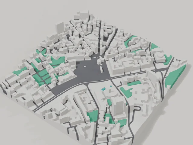
What your 3D model of Kyiv will show
An 800 × 800 m square around the centre of Kyiv holds about 426 buildings, each with its real height. The tallest building in frame has 18 floors, 4.6 on average.
What the area is like: low-rise blocks — streets and terrain show especially well.
Green areas printed in a separate colour: Володимирська гірка, Канадський сквер, Музичний сквер, Українського радіо.
Recognisable places inside the area: Церква Святого Олександра, Національна музична академія України, Міжнародний центр культури і мистецтв, Каплиця Непорочного Серця Матері Божої і Новомучеників Українського Народу, Лядські ворота, Знак відліку відстаней.
Data: OpenStreetMap, 800 × 800 m area.
Districts & landmarks
3D map by district: Kyiv
3D map of a street in Kyiv
- Lvivska Square
- Odesa Square, Kyiv
- Instytutska Street
- Mahdeburzkoho prava Alley
- Biloruska Street, Kyiv
- Yevhen Konovalets Street, Kyiv
- Petra Bolbochana Street
- Yakuba Kolasa Street, Kyiv
- Heroiv UPA Square
- Holosiivska Square
- Lyuteranska Street
- Alley of Heroes of the Heavenly Hundred
- Vokzalna Square, Kyiv
- Yevhena Sverstiuka Street, Kyiv
- Yevhen Chykalenko Street, Kyiv
- Yezhy Gedroitsia Street, Kyiv
- Ivana Franka Street
- John Paul II Street, Kyiv
- Akademika Bohomoltsia Street
- Arkhitektora Horodetskoho Street
- Heroiv Dnipra Street, Kyiv
- Deputatskaya Street, Kyiv
- Kuchmyn Yar Street
- Ovanesa Tumaniana Street
- Oleksy Tykhoho Street
- Honoré de Balzac Street
- Rohnidynska Street, Kyiv
- Symona Petliury Street
- Shota Rustaveli Street, Kyiv
- Yanky Kupaly Street, Kyiv
- Yanusha Korchaka Street
- Demiivska Square, Kyiv
- Derevlianska Street, Kyiv
- Estonska Street
- Kyrylivska Street, Kyiv
- Kolektorna Street, Kyiv
- Krakivska Street, Kyiv
- Kiltseva Road, Kyiv
- Luhova Street
- Mykhailivska Street, Kyiv
Prices — Kyiv
- 3D city map — S (≈5.5 cm)350 ₴ · ≈8 €
- 3D city map — M (≈8 cm)500 ₴ · ≈12 €
- 3D city map — L (≈11 cm)750 ₴ · ≈18 €
- 3D city map — XL (≈15 cm)1250 ₴ · ≈30 €
- 3D city map — 20 cm1650 ₴ · ≈40 €
- Terrain relief (option)+100 ₴
- Fridge magnet map (≈6 cm)210 ₴ · ≈5 €
- Map keychain (3D print)from 170 ₴ · ≈4 €
FAQ
- How many buildings will the 3D model of Kyiv have?
- An 8 cm map of an 800 × 800 m area holds about 426 buildings, the tallest with 18 floors. Resize or move the frame and the count changes — the builder preview shows the exact result.
- Will Церква Святого Олександра be visible on the model?
- Yes — Церква Святого Олександра lies inside the area shown for this page. Move the frame in the builder to put it right in the centre.
- How long does production take?
- Making a map or keychain with a Kyiv district takes 2–4 business days, then the model goes to shipping.
- Which area of Kyiv should I pick?
- Mixed areas look best: some streets, a park or water — the district stays recognizable at first glance. A too-large area makes details too small.
- Can I add text on the back?
- Yes — the back of a keychain or map can carry your own text: a name, a date, coordinates or a city name. The option is available in the builder before checkout.
- How is delivery to Kyiv handled?
- Delivery by Nova Poshta across Ukraine. Shipping cost is charged separately at the carrier's rate.
- How do I pay for an order?
- Card payment online (Visa/Mastercard via LiqPay) or cash on delivery — your choice at checkout.