3D model of Lviv — a model of your neighbourhood
A 3D map of Lviv is a tactile three-dimensional model of a district: streets, buildings with real heights, parks and rivers from OpenStreetMap data. Pick any district of Lviv in the builder — the model is ready in minutes as a 3MF or STL for Bambu Studio or PrusaSlicer.
No 3D printer? We print the map or a Lviv map keychain in eco-friendly Eco PLA and ship across Ukraine. A perfect gift for anyone who loves their city.
In three dimensions Lviv is recognised by two things: the line drawn by the Poltva and the mass of Lviv Opera House within dense blocks. Everything else is context holding those anchors.
With 172 km² of area, one model usually covers a district rather than the whole city. Here at 4,177 people per km² the centre becomes a solid relief of rooftops, with streets reading as cuts through it.
The city is roughly 750 years old, so regular later blocks sit next to an irregular historic centre.
Administratively this is Lviv Oblast. The sweet spot for a single model is 1–3 km² — beyond that, narrow streets stop resolving at a 0.4 mm nozzle.
Lviv at a glance
- Population
- 717,273 (2022)
- First mentioned
- 1256
- Area
- 172 km²
- Water
- Poltva
- Region
- Lviv Oblast
- Landmark
- Lviv Opera House
- Density
- 4,177 people/km²
- City age
- 770 years
Lviv was first recorded in 1256 and covers an area of nearly 172 square kilometers with about 717 thousand residents. The Lviv Opera stands as the city landmark, and the Poltva River flows through the regional center. This scale model captures an 800 by 800 meter square section featuring 745 buildings. Structures here average three and a half floors, while the tallest building rises to eight levels.
The miniature shows the Archcathedral Basilica of the Assumption, Lubomirski Palace, Korniakt Tower, Lviv Historical Museum, the City Arsenal, and the Assumption Church. Green zones include Yevhen Malaniuk Square, Na Valakh Park, the Space of Synagogues, Bernardengarden, and the path of the Poltva. Anyone can buy a 3D model as an eight-centimeter desk piece or order a map area scaled down into a keychain.
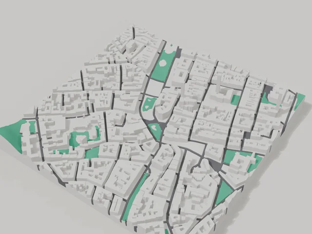
What your 3D model of Lviv will show
An 800 × 800 m square around the centre of Lviv holds about 745 buildings, each with its real height. The tallest building in frame has 8 floors, 3.5 on average.
What the area is like: low-rise blocks — streets and terrain show especially well; a very dense area — the model will be packed with detail.
Green areas printed in a separate colour: Євгена Маланюка, На Валах (Губернаторські Вали), Простір Синагог, Бернарденгарден.
Water in frame: Полтва — slightly lower than the ground, so the shoreline reads in relief.
Recognisable places inside the area: Архікафедральна базиліка Успіння Пресвятої Діви Марії, Палац Любомирських, Кам'яниця Корнякта, Львівський історичний музей, Арсенал, Львівський державний історичний музей старовинної зброї, Успенська церква.
Data: OpenStreetMap, 800 × 800 m area.
Districts & landmarks
3D map by district: Lviv
3D map of a street in Lviv
- Old Market Square
- Halytska Square, Lviv
- Soborna Square, Lviv
- Brativ Rohatyntsiv Street, Lviv
- Volodymyra Velykoho Street, Lviv
- Вулиця Вірменська
- Hetmana Mazepy street, Lviv
- Kulparkivska Street
- Kropyvnytskoho Square, Lviv
- Vyhody Street, Lviv
- Havryshkevycha Street, Lviv
- Honty Street, Lviv
- Zamarstynivska Street
- Kalicha Hora Street, Lviv
- Kleparivska Street
- Kniahyni Olhy Street, Lviv
- Mstyslava Udatnoho Street, Lviv
- Kulisha Street, Lviv
- Lesi Ukrainky Street
- Liubinska Street
- Naukova Street
- Okruzhna Street
- Beryndy Street, Lviv
- Banakha Street, Lviv
- Universytetska Street, Lviv
- Chernivetska Street, Lviv
- Yaponska Street, Lviv
- Kniazia Sviatoslava Square, Lviv
- Petrushevych Square, Lviv
- St. George's square, Lviv
- st. John Paul II street
Prices — Lviv
- 3D city map — S (≈5.5 cm)350 ₴ · ≈8 €
- 3D city map — M (≈8 cm)500 ₴ · ≈12 €
- 3D city map — L (≈11 cm)750 ₴ · ≈18 €
- 3D city map — XL (≈15 cm)1250 ₴ · ≈30 €
- 3D city map — 20 cm1650 ₴ · ≈40 €
- Terrain relief (option)+100 ₴
- Fridge magnet map (≈6 cm)210 ₴ · ≈5 €
- Map keychain (3D print)from 170 ₴ · ≈4 €
FAQ
- How many buildings will the 3D model of Lviv have?
- An 8 cm map of an 800 × 800 m area holds about 745 buildings, the tallest with 8 floors. Resize or move the frame and the count changes — the builder preview shows the exact result.
- Will Архікафедральна базиліка Успіння Пресвятої Діви Марії be visible on the model?
- Yes — Архікафедральна базиліка Успіння Пресвятої Діви Марії lies inside the area shown for this page. Move the frame in the builder to put it right in the centre.
- How long does production take?
- Making a map or keychain with a Lviv district takes 2–4 business days, then the model goes to shipping.
- Which area of Lviv should I pick?
- Mixed areas look best: some streets, a park or water — the district stays recognizable at first glance. A too-large area makes details too small.
- Can I add text on the back?
- Yes — the back of a keychain or map can carry your own text: a name, a date, coordinates or a city name. The option is available in the builder before checkout.
- How is delivery to Lviv handled?
- Delivery by Nova Poshta across Ukraine. Shipping cost is charged separately at the carrier's rate.
- How do I pay for an order?
- Card payment online (Visa/Mastercard via LiqPay) or cash on delivery — your choice at checkout.