3D model of Kropyvnytskyi — a model of your neighbourhood
A 3D map of Kropyvnytskyi is a tactile three-dimensional model of a district: streets, buildings with real heights, parks and rivers from OpenStreetMap data. Pick any district of Kropyvnytskyi in the builder — the model is ready in minutes as a 3MF or STL for Bambu Studio or PrusaSlicer.
No 3D printer? We print the map or a Kropyvnytskyi map keychain in eco-friendly Eco PLA and ship across Ukraine. A perfect gift for anyone who loves their city.
Relatively young fabric (272 years) means an ordered street grid — the model comes out graphic and easy to read.
Fortress of St. Elizabeth and the Inhul are what people look for first on the model. The remaining blocks act as a backdrop that sets the scale.
At 103 km² the city fits into a single model without losing detail. Meanwhile a density of 2,133 people per km² gives an even block rhythm, and the map reads as one continuous fabric.
The region is Kirovohrad Oblast. A print usually covers 1–3 km² around the centre: at that scale buildings stay separate volumes instead of merging into a slab.
Kropyvnytskyi at a glance
- Population
- 219,676 (2022)
- Founded
- 1754
- Area
- 103 km²
- Water
- Inhul
- Region
- Kirovohrad Oblast
- Landmark
- Fortress of St. Elizabeth
- Density
- 2,133 people/km²
- City age
- 272 years
Kropyvnytskyi was founded in 1754, and its landmark is still the Fortress of St. Elizabeth where the city began. About 220 thousand people live here, and the Inhul river crosses the centre. The 800 by 800 metre square we show for the 3D map holds 440 buildings, 2.1 floors on average, the tallest at 12 floors. Low, dense blocks give a crisp street pattern on the model.
The area includes the Inhul, Kozachyi Ostriv park and several small squares, such as the one named after the first Yelysavethrad tram. Among the buildings is the Kropyvnytskyi Theatre, one of the most recognisable places in the centre. A map like this suits people who grew up here and moved away: finding their own street is easy. To buy a 3D model of your own district, move the frame in the builder to where you live. Buildings on the model keep their real height.
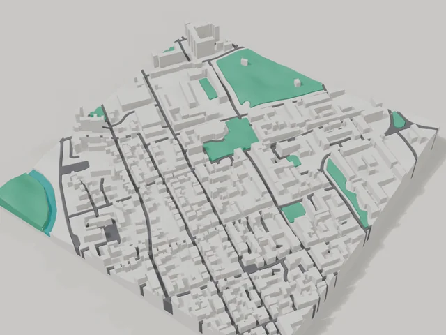
What your 3D model of Kropyvnytskyi will show
An 800 × 800 m square around the centre of Kropyvnytskyi holds about 440 buildings, each with its real height. The tallest building in frame has 12 floors, 2.1 on average.
What the area is like: low-rise blocks — streets and terrain show especially well.
Green areas printed in a separate colour: Сквер «Першого Єлисаветградського трамвая», Сквер «Солдатський», Сквер ім. Б.Вінтенка, "Козачий острів" парк.
Water in frame: Інгул — slightly lower than the ground, so the shoreline reads in relief.
Recognisable places inside the area: Театр ім. М. Л. Кропивницького, Пам'ятна дошка бійцям 3-го полку, М. Л. Кропивницькому, В. К. Винниченку, Пам'ятний знак Воїнам-спортсменам, що віддали життя за Батьківщину.
Data: OpenStreetMap, 800 × 800 m area.
Prices — Kropyvnytskyi
- 3D city map — S (≈5.5 cm)350 ₴ · ≈8 €
- 3D city map — M (≈8 cm)500 ₴ · ≈12 €
- 3D city map — L (≈11 cm)750 ₴ · ≈18 €
- 3D city map — XL (≈15 cm)1250 ₴ · ≈30 €
- 3D city map — 20 cm1650 ₴ · ≈40 €
- Terrain relief (option)+100 ₴
- Fridge magnet map (≈6 cm)210 ₴ · ≈5 €
- Map keychain (3D print)from 170 ₴ · ≈4 €
FAQ
- How many buildings will the 3D model of Kropyvnytskyi have?
- An 8 cm map of an 800 × 800 m area holds about 440 buildings, the tallest with 12 floors. Resize or move the frame and the count changes — the builder preview shows the exact result.
- Will Театр ім. М. Л. Кропивницького be visible on the model?
- Yes — Театр ім. М. Л. Кропивницького lies inside the area shown for this page. Move the frame in the builder to put it right in the centre.
- How long does production take?
- Making a map or keychain with a Kropyvnytskyi district takes 2–4 business days, then the model goes to shipping.
- Which area of Kropyvnytskyi should I pick?
- Mixed areas look best: some streets, a park or water — the district stays recognizable at first glance. A too-large area makes details too small.
- Can I add text on the back?
- Yes — the back of a keychain or map can carry your own text: a name, a date, coordinates or a city name. The option is available in the builder before checkout.
- How is delivery to Kropyvnytskyi handled?
- Delivery by Nova Poshta across Ukraine. Shipping cost is charged separately at the carrier's rate.
- How do I pay for an order?
- Card payment online (Visa/Mastercard via LiqPay) or cash on delivery — your choice at checkout.