3D model of Bilhorod-Dnistrovskyi — buy a printed city map
A model of Bilhorod-Dnistrovskyi is not an off-the-shelf souvenir — it is your own place: your yard, street or district. You choose the area, see a free preview straight away and we ship the printed 3D map.
Maps from ≈€8, map keychains from ≈€4. Production takes 2–4 working days. You can also buy just the 3MF file to print yourself.
Bilhorod-Dnistrovskyi is a city in Odesa Oblast with 47,727 residents (2020) and about 1,540 people/km². Odesa lies 43 km to the north-east.
On a 3D map the city is recognised first by its water (Dniester Estuary) and its landmark, Akkerman Fortress — the anchors people look for first.
The city covers about 31 km², so the centre with its main streets fits one 11–15 cm map with full detail.
Bilhorod Dnistrovskyi stands on the shore of the Dniester estuary, 43 kilometres from Odesa. It is one of the oldest towns in Ukraine, and its Akkerman fortress with towers above the water is among the largest surviving fortresses in the country. About 47727 people lived here according to 2020 data, on 31 square kilometres.
The 800 by 800 metre model square holds 1093 buildings, so the centre comes out dense and detailed on the map. The town is low rise, with an average of 1.8 floors and the tallest at 5 floors. Izmailskyi square is printed in green, and the area includes the Ascension Cathedral. You can move the frame closer to the fortress and the estuary or onto your own street.
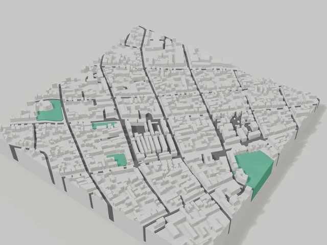
Bilhorod-Dnistrovskyi at a glance
- Population
- 47,727 (2020)
- Area
- 31 km²
- Density
- 1,540 people/km²
- Region
- Odesa Oblast
- Water
- Dniester Estuary
- Landmark
- Akkerman Fortress
What your 3D model of Bilhorod-Dnistrovskyi will show
An 800 × 800 m square around the centre of Bilhorod-Dnistrovskyi holds about 1,093 buildings, each with its real height. The tallest building in frame has 5 floors, 1.8 on average.
What the area is like: low-rise blocks — streets and terrain show especially well; a very dense area — the model will be packed with detail.
Green areas printed in a separate colour: Сквер Ізмаїльський, Парк Перемоги.
Recognisable places inside the area: Свято-Вознесенський собор, Головний корпус, Відділ обслуговування дітей та юнацтва Білгород-Дністровської публічної бібліотеки, Воїнам Другої світової війни, Військові підрозділи, які брали участь у звільненні м. Білгорода-Дністровського.
Data: OpenStreetMap, 800 × 800 m area.
How to order a 3D map of Bilhorod-Dnistrovskyi
- Open the builder — it starts right at the centre of Bilhorod-Dnistrovskyi. Move the frame to your district, street or yard.
- Choose size and style (with or without relief) — the preview is ready in a few minutes.
- Order the print and enter the delivery details — we print it in 2–4 working days.
Prices — Bilhorod-Dnistrovskyi
- Carte 3D de ville — S (≈5,5 cm)350 ₴ · ≈8 €
- Carte 3D de ville — M (≈8 cm)500 ₴ · ≈12 €
- Carte 3D de ville — L (≈11 cm)750 ₴ · ≈18 €
- Carte 3D de ville — XL (≈15 cm)1250 ₴ · ≈30 €
- Carte 3D de ville — 20 cm1650 ₴ · ≈40 €
- Relief du terrain (option)+100 ₴
- Aimant-carte de frigo (≈6 cm)210 ₴ · ≈5 €
- Porte-clés carte (impression 3D)dès 170 ₴ · ≈4 €
FAQ
- How many buildings will the 3D model of Bilhorod-Dnistrovskyi have?
- An 8 cm map of an 800 × 800 m area holds about 1,093 buildings, the tallest with 5 floors. Resize or move the frame and the count changes — the builder preview shows the exact result.
- Will Свято-Вознесенський собор be visible on the model?
- Yes — Свято-Вознесенський собор lies inside the area shown for this page. Move the frame in the builder to put it right in the centre.
- Combien de temps prend la fabrication ?
- La fabrication d'une carte ou d'un porte-clés avec un quartier de Bilhorod-Dnistrovskyi prend 1 à 3 jours ouvrés, puis le modèle part en livraison.
- Puis-je ajouter du texte au dos ?
- Oui — le dos d'un porte-clés ou d'une carte peut porter votre texte : un nom, une date, des coordonnées ou un nom de ville. L'option est dans le configurateur avant la commande.