3D model of Svitlovodsk — buy a printed city map
A model of Svitlovodsk is not an off-the-shelf souvenir — it is your own place: your yard, street or district. You choose the area, see a free preview straight away and we ship the printed 3D map.
Maps from ≈€8, map keychains from ≈€4. Production takes 2–4 working days. You can also buy just the 3MF file to print yourself.
Svitlovodsk is a city in Kirovohrad Oblast with 45,312 residents (2017) and about 1,007 people/km². Kropyvnytskyi lies 95 km to the south-west.
On a 3D map the city is recognised first by its water (Dnipro) and its landmark, Kremenchuk Hydroelectric Station — the anchors people look for first.
At 45 km² the whole city will not fit one model — people usually pick the centre or their own neighbourhood at 8–11 cm.
Svitlovodsk was founded in 1954 on the bank of the Dnipro together with the construction of the Kremenchuk hydroelectric plant, which is still the town's best known landmark. Kropyvnytskyi is 95 kilometres away. About 45312 people lived here according to the 2017 estimate, on 45 square kilometres.
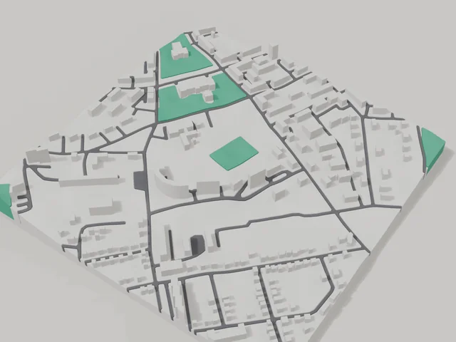
The 800 by 800 metre model square holds 207 buildings with an average of 4.5 floors and the tallest at 9 floors. The town was built to a plan, so the blocks on the map are regular and clear. Shevchenko park is printed in green, and the area includes St Andrew's church and the local history museum. Buildings on the model keep their real height.
Svitlovodsk at a glance
- Population
- 45,312 (2017)
- Area
- 45 km²
- Density
- 1,007 people/km²
- Region
- Kirovohrad Oblast
- Water
- Dnipro
- Landmark
- Kremenchuk Hydroelectric Station
- Founded
- 1954
What your 3D model of Svitlovodsk will show
An 800 × 800 m square around the centre of Svitlovodsk holds about 207 buildings, each with its real height. The tallest building in frame has 9 floors, 4.5 on average.
What the area is like: low-rise blocks — streets and terrain show especially well.
Green areas printed in a separate colour: Парк ім. Т.Г. Шевченка.
Recognisable places inside the area: Церква Андрія Первозванного, Міський краєзнавчий музей.
Data: OpenStreetMap, 800 × 800 m area.
How to order a 3D map of Svitlovodsk
- Open the builder — it starts right at the centre of Svitlovodsk. Move the frame to your district, street or yard.
- Choose size and style (with or without relief) — the preview is ready in a few minutes.
- Order the print and enter the delivery details — we print it in 2–4 working days.
Prices — Svitlovodsk
- Mapa 3D de ciudad — S (≈5,5 cm)350 ₴ · ≈8 €
- Mapa 3D de ciudad — M (≈8 cm)500 ₴ · ≈12 €
- Mapa 3D de ciudad — L (≈11 cm)750 ₴ · ≈18 €
- Mapa 3D de ciudad — XL (≈15 cm)1250 ₴ · ≈30 €
- Mapa 3D de ciudad — 20 cm1650 ₴ · ≈40 €
- Relieve del terreno (opción)+100 ₴
- Imán-mapa de nevera (≈6 cm)210 ₴ · ≈5 €
- Llavero-mapa (impresión 3D)desde 170 ₴ · ≈4 €
FAQ
- How many buildings will the 3D model of Svitlovodsk have?
- An 8 cm map of an 800 × 800 m area holds about 207 buildings, the tallest with 9 floors. Resize or move the frame and the count changes — the builder preview shows the exact result.
- Will Церква Андрія Первозванного be visible on the model?
- Yes — Церква Андрія Первозванного lies inside the area shown for this page. Move the frame in the builder to put it right in the centre.
- ¿Cómo es el envío a Svitlovodsk?
- Envío por Nova Poshta en Ucrania. El coste de envío se cobra aparte según la tarifa del transportista.
- ¿Cuánto tarda la fabricación?
- Fabricar un mapa o un llavero con un distrito de Svitlovodsk tarda 2–4 días hábiles, luego el modelo pasa al envío.