3D model of Enerhodar — buy a printed city map
A model of Enerhodar is not an off-the-shelf souvenir — it is your own place: your yard, street or district. You choose the area, see a free preview straight away and we ship the printed 3D map.
Maps from ≈€8, map keychains from ≈€4. Production takes 2–4 working days. You can also buy just the 3MF file to print yourself.
Enerhodar is a city in Zaporizhzhia Oblast with 52,237 residents (2022) and about 82 people/km². Zaporizhzhia lies 52 km to the north-east.
On a 3D map the city is recognised first by its water (Dnipro) and its landmark, Zaporizhzhia NPP — the anchors people look for first.
The city is large (635 km²), so a single district or street works best; for the whole city, a multi-tile panel.
Enerhodar was founded in 1970 on the bank of the Dnipro as a town for the workers of the Zaporizhzhia nuclear power plant, the largest in Europe. Zaporizhzhia is 52 kilometres away. With the water included the town covers 635 square kilometres, so density is formally very low at 82 people per square kilometre. About 52237 people lived here in 2022, and the town has been under occupation since that year.
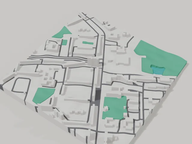
The 800 by 800 metre model square holds 75 buildings. The average height is 6.8 floors and the tallest buildings have 14 floors, so the map shows the large housing blocks typical of a young town. The city park is printed in green. The model keeps the pre war map for people waiting to return home.
Enerhodar at a glance
- Population
- 52,237 (2022)
- Area
- 635 km²
- Density
- 82 people/km²
- Region
- Zaporizhzhia Oblast
- Water
- Dnipro
- Landmark
- Zaporizhzhia NPP
- Founded
- 1970
What your 3D model of Enerhodar will show
An 800 × 800 m square around the centre of Enerhodar holds about 75 buildings, each with its real height. The tallest building in frame has 14 floors, 6.8 on average.
What the area is like: mid-rise blocks — buildings read clearly one by one; an open area with plenty of free space.
Green areas printed in a separate colour: Міський парк культури та відпочинку, Юність.
Recognisable places inside the area: Храм на честь святителя Луки Кримського (УПЦ МП), ЗіС-3, Тарасу Шевченко.
Data: OpenStreetMap, 800 × 800 m area.
How to order a 3D map of Enerhodar
- Open the builder — it starts right at the centre of Enerhodar. Move the frame to your district, street or yard.
- Choose size and style (with or without relief) — the preview is ready in a few minutes.
- Order the print and enter the delivery details — we print it in 2–4 working days.
Prices — Enerhodar
- Mapa 3D miasta — S (≈5,5 cm)350 ₴ · ≈8 €
- Mapa 3D miasta — M (≈8 cm)500 ₴ · ≈12 €
- Mapa 3D miasta — L (≈11 cm)750 ₴ · ≈18 €
- Mapa 3D miasta — XL (≈15 cm)1250 ₴ · ≈30 €
- Mapa 3D miasta — 20 cm1650 ₴ · ≈40 €
- Relief terenu (opcja)+100 ₴
- Magnes-mapa na lodówkę (≈6 cm)210 ₴ · ≈5 €
- Brelok-mapa (druk 3D)od 170 ₴ · ≈4 €
FAQ
- How many buildings will the 3D model of Enerhodar have?
- An 8 cm map of an 800 × 800 m area holds about 75 buildings, the tallest with 14 floors. Resize or move the frame and the count changes — the builder preview shows the exact result.
- Will Храм на честь святителя Луки Кримського (УПЦ МП) be visible on the model?
- Yes — Храм на честь святителя Луки Кримського (УПЦ МП) lies inside the area shown for this page. Move the frame in the builder to put it right in the centre.
- Jak wygląda dostawa do miasta Enerhodar?
- Dostawa Nova Poshta na Ukrainie. Koszt dostawy naliczany osobno według taryfy przewoźnika.
- Ile trwa wykonanie?
- Wykonanie mapy lub breloka z dzielnicą miasta Enerhodar zajmuje 2–4 dni robocze, po czym model trafia do wysyłki.