3D model of Donetsk — buy a printed city map
Want to buy a 3D model of Donetsk or order a map of your own neighbourhood? We print tactile maps from real OpenStreetMap data: streets, buildings with real heights, parks and water. Pick the area in the builder, preview it for free and order the print.
Maps from ≈€8, map keychains from ≈€4. Production takes 2–4 working days. You can also buy just the 3MF file to print yourself.
Donetsk is a city in Donetsk Oblast with 901,645 residents (2022) and about 2,519 people/km². Zaporizhzhia lies 199 km to the west.
On a 3D map the city is recognised first by its water (Kalmius) and its landmark, Donbas Arena — the anchors people look for first.
The city is large (358 km²), so a single district or street works best; for the whole city, a multi-tile panel.
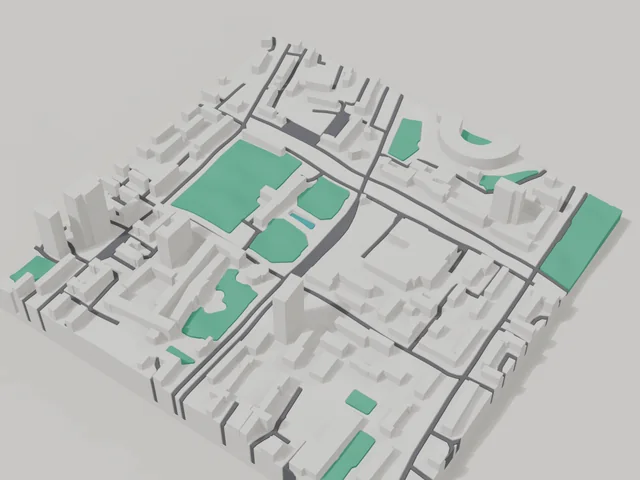
Donetsk was founded in 1869, and more than 900 thousand people lived here before 2022. The city stands on the Kalmius river, and Donbas Arena became its landmark. The area for the 3D map is an 800 by 800 metre square in the centre: 110 buildings, some of them high rise, the tallest at 24 floors and 5.9 floors on average. On the model this gives a strong skyline with a few tall volumes.
The frame includes the Park of Forged Figures and a large city park, plus the monuments to Serhiy Bubka and to John Hughes, whose works gave rise to the city. For many people this is the place where home remains, so the map is often ordered as a keepsake: you can move the frame onto your own street or yard. Order a map of the centre or buy a 3D model of your district in the builder, with every building at its real height.
Donetsk at a glance
- Population
- 901,645 (2022)
- Area
- 358 km²
- Density
- 2,519 people/km²
- Region
- Donetsk Oblast
- Water
- Kalmius
- Landmark
- Donbas Arena
- Founded
- 1869
What your 3D model of Donetsk will show
An 800 × 800 m square around the centre of Donetsk holds about 110 buildings, each with its real height. The tallest building in frame has 24 floors, 5.9 on average.
What the area is like: mid-rise blocks — buildings read clearly one by one; an open area with plenty of free space.
Green areas printed in a separate colour: Парк кованих фігур.
Recognisable places inside the area: Пам'ятник Сергію Бубці, Пам'ятник Джону Юзу, Викладачам, вихованцям та співробітникам ДПі, що загинули у роки війни, Пам'ятник Святому Великомученику Юрію-Змієборцю, Царь Пушка, Донецький національний університет економіки і торгівлі. Корпус №5.
Data: OpenStreetMap, 800 × 800 m area.
How to order a 3D map of Donetsk
- Open the builder — it starts right at the centre of Donetsk. Move the frame to your district, street or yard.
- Choose size and style (with or without relief) — the preview is ready in a few minutes.
- Order the print and enter the delivery details — we print it in 2–4 working days.
Prices — Donetsk
- Mapa 3D miasta — S (≈5,5 cm)350 ₴ · ≈8 €
- Mapa 3D miasta — M (≈8 cm)500 ₴ · ≈12 €
- Mapa 3D miasta — L (≈11 cm)750 ₴ · ≈18 €
- Mapa 3D miasta — XL (≈15 cm)1250 ₴ · ≈30 €
- Mapa 3D miasta — 20 cm1650 ₴ · ≈40 €
- Relief terenu (opcja)+100 ₴
- Magnes-mapa na lodówkę (≈6 cm)210 ₴ · ≈5 €
- Brelok-mapa (druk 3D)od 170 ₴ · ≈4 €
FAQ
- How many buildings will the 3D model of Donetsk have?
- An 8 cm map of an 800 × 800 m area holds about 110 buildings, the tallest with 24 floors. Resize or move the frame and the count changes — the builder preview shows the exact result.
- Will Пам'ятник Сергію Бубці be visible on the model?
- Yes — Пам'ятник Сергію Бубці lies inside the area shown for this page. Move the frame in the builder to put it right in the centre.
- Jak wygląda dostawa do miasta Donetsk?
- Dostawa Nova Poshta na Ukrainie. Koszt dostawy naliczany osobno według taryfy przewoźnika.
- Ile trwa wykonanie?
- Wykonanie mapy lub breloka z dzielnicą miasta Donetsk zajmuje 2–4 dni robocze, po czym model trafia do wysyłki.