3D model of Mariupol — buy a printed city map
A model of Mariupol is not an off-the-shelf souvenir — it is your own place: your yard, street or district. You choose the area, see a free preview straight away and we ship the printed 3D map.
Maps from ≈€8, map keychains from ≈€4. Production takes 2–4 working days. You can also buy just the 3MF file to print yourself.
Mariupol is a city in Donetsk Oblast with 425,681 residents (2022) and about 1,745 people/km². Zaporizhzhia lies 198 km to the north-west.
On a 3D map the city is recognised first by its water (Sea of Azov) and its landmark, Drama Theatre — the anchors people look for first.
The city is large (244 km²), so a single district or street works best; for the whole city, a multi-tile panel.
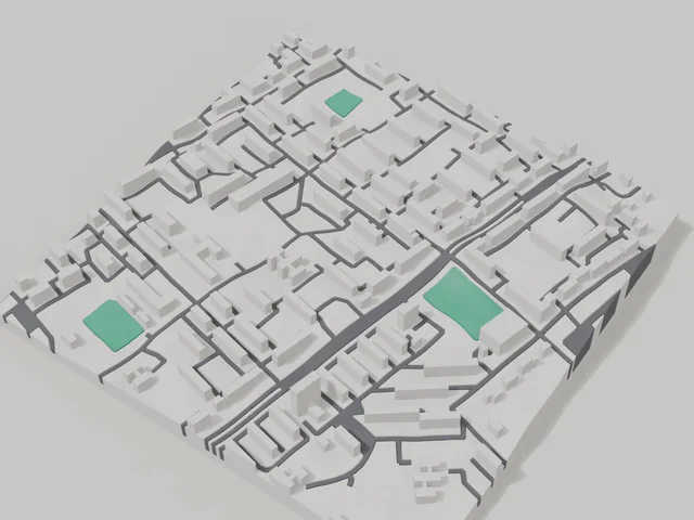
Mariupol was founded in 1778 on the shore of the Sea of Azov, and more than 425 thousand people lived here at the start of 2022. The city's landmark was its Drama Theatre. The area for the 3D map is an 800 by 800 metre square in the centre: 169 buildings, 3.4 floors on average, the tallest at 8 floors. This is the old part of the city with low-rise blocks that are easy to recognise on a model.
The frame includes Independence Square and the building of the Donetsk State University of Management. Mariupol is often ordered by people who had to leave: a map of their home district keeps it the way they remember it. In the builder you can place the frame exactly on your house, your school or the seafront. Buy a 3D model or order a map for yourself or as a gift for your family; the model preview is free.
Mariupol at a glance
- Population
- 425,681 (2022)
- Area
- 244 km²
- Density
- 1,745 people/km²
- Region
- Donetsk Oblast
- Water
- Sea of Azov
- Landmark
- Drama Theatre
- Founded
- 1778
What your 3D model of Mariupol will show
An 800 × 800 m square around the centre of Mariupol holds about 169 buildings, each with its real height. The tallest building in frame has 8 floors, 3.4 on average.
What the area is like: low-rise blocks — streets and terrain show especially well.
Green areas printed in a separate colour: Незалежності площа.
Recognisable places inside the area: Донецький державний університет управління.
Data: OpenStreetMap, 800 × 800 m area.
How to order a 3D map of Mariupol
- Open the builder — it starts right at the centre of Mariupol. Move the frame to your district, street or yard.
- Choose size and style (with or without relief) — the preview is ready in a few minutes.
- Order the print and enter the delivery details — we print it in 2–4 working days.
Prices — Mariupol
- Hartă 3D a orașului — S (≈5,5 cm)350 ₴ · ≈8 €
- Hartă 3D a orașului — M (≈8 cm)500 ₴ · ≈12 €
- Hartă 3D a orașului — L (≈11 cm)750 ₴ · ≈18 €
- Hartă 3D a orașului — XL (≈15 cm)1250 ₴ · ≈30 €
- Hartă 3D a orașului — 20 cm1650 ₴ · ≈40 €
- Relieful terenului (opțiune)+100 ₴
- Magnet de frigider cu hartă (≈6 cm)210 ₴ · ≈5 €
- Breloc cu hartă (imprimare 3D)de la 170 ₴ · ≈4 €
FAQ
- How many buildings will the 3D model of Mariupol have?
- An 8 cm map of an 800 × 800 m area holds about 169 buildings, the tallest with 8 floors. Resize or move the frame and the count changes — the builder preview shows the exact result.
- Will Донецький державний університет управління be visible on the model?
- Yes — Донецький державний університет управління lies inside the area shown for this page. Move the frame in the builder to put it right in the centre.
- Can I add text on the back?
- Yes — the back of a keychain or map can carry your own text: a name, a date, coordinates or a city name. The option is available in the builder before checkout.
- How do I pay for an order?
- Card payment online (Visa/Mastercard via LiqPay) or cash on delivery — your choice at checkout.