3D model of Drohobych — buy a printed city map
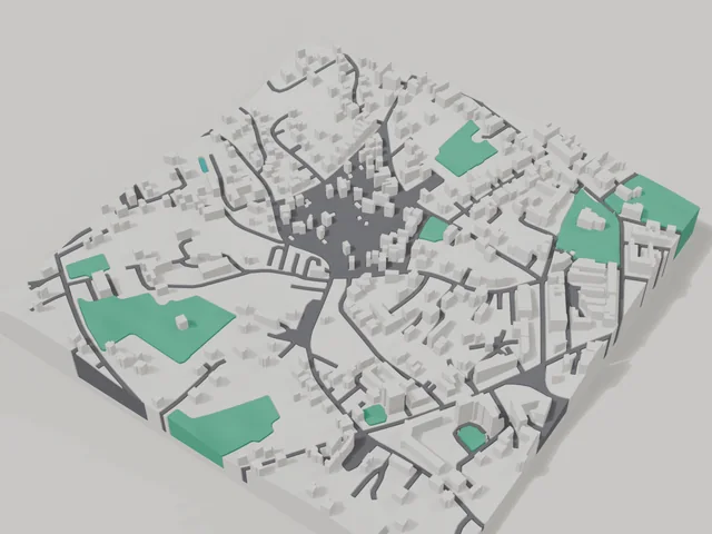
The 3D map of Drohobych is printed from open map data: buildings get their real height, roads their width, parks and water a colour of their own. Any part of the city can be ordered, from the centre to the outskirts.
Maps from ≈€8, map keychains from ≈€4. Production takes 2–4 working days. You can also buy just the 3MF file to print yourself.
Drohobych is a city in Lviv Oblast with 73,682 residents (2022) and about 1,797 people/km². Lviv lies 67 km to the north-east.
On a 3D map the city is recognised first by its water (Tysmenytsia) and its landmark, St. George's Church — the anchors people look for first.
At 41 km² the whole city will not fit one model — people usually pick the centre or their own neighbourhood at 8–11 cm.
Drohobych sits on the Tysmenytsia river 67 kilometres from Lviv, and the first written mention of the town dates to 1387. It grew rich on salt works, and that wealth still shows in the centre: the wooden Church of St George is on the UNESCO list, and nearby stand the Church of St Bartholomew with its old bell tower and the Holy Trinity Cathedral.
The 800 by 800 metre square around the centre holds 584 buildings. The town is low rise, with an average of 1.7 floors and the tallest building at 9 floors, so the model shows the old roofs and the lanes between them clearly. Na Valakh park, Stepan Bandera park and Mariinskyi square are printed in green. Buildings on the model keep their real height from OSM data.
Drohobych at a glance
- Population
- 73,682 (2022)
- Area
- 41 km²
- Density
- 1,797 people/km²
- Region
- Lviv Oblast
- Water
- Tysmenytsia
- Landmark
- St. George's Church
- First mentioned
- 1387
What your 3D model of Drohobych will show
An 800 × 800 m square around the centre of Drohobych holds about 584 buildings, each with its real height. The tallest building in frame has 9 floors, 1.7 on average.
What the area is like: low-rise blocks — streets and terrain show especially well.
Green areas printed in a separate colour: Парк ім. Степана Бандери, парк На Валах, Маріїнський сквер.
Recognisable places inside the area: Церква святого Юра, Костел Святого Варфоломія, Дзвіниця костелу святого Варфоломія, Церква Воздвиження Чесного Хреста, Катедральний собор Пресвятої Трійці, Альтер.
Data: OpenStreetMap, 800 × 800 m area.
How to order a 3D map of Drohobych
- Open the builder — it starts right at the centre of Drohobych. Move the frame to your district, street or yard.
- Choose size and style (with or without relief) — the preview is ready in a few minutes.
- Order the print and enter the delivery details — we print it in 2–4 working days.
Prices — Drohobych
- Hartă 3D a orașului — S (≈5,5 cm)350 ₴ · ≈8 €
- Hartă 3D a orașului — M (≈8 cm)500 ₴ · ≈12 €
- Hartă 3D a orașului — L (≈11 cm)750 ₴ · ≈18 €
- Hartă 3D a orașului — XL (≈15 cm)1250 ₴ · ≈30 €
- Hartă 3D a orașului — 20 cm1650 ₴ · ≈40 €
- Relieful terenului (opțiune)+100 ₴
- Magnet de frigider cu hartă (≈6 cm)210 ₴ · ≈5 €
- Breloc cu hartă (imprimare 3D)de la 170 ₴ · ≈4 €
FAQ
- How many buildings will the 3D model of Drohobych have?
- An 8 cm map of an 800 × 800 m area holds about 584 buildings, the tallest with 9 floors. Resize or move the frame and the count changes — the builder preview shows the exact result.
- Will Церква святого Юра be visible on the model?
- Yes — Церква святого Юра lies inside the area shown for this page. Move the frame in the builder to put it right in the centre.
- Which area of Drohobych should I pick?
- Mixed areas look best: some streets, a park or water — the district stays recognizable at first glance. A too-large area makes details too small.
- How is delivery to Drohobych handled?
- Delivery by Nova Poshta across Ukraine. Shipping cost is charged separately at the carrier's rate.